4x4 TRAILS & STORIES CAMP SYNCRO PHOTOS SYNCRONAUTS
Trail Links:
Bear Creek Trail
Wednesday, July 21, 2010
By: Jim Davis
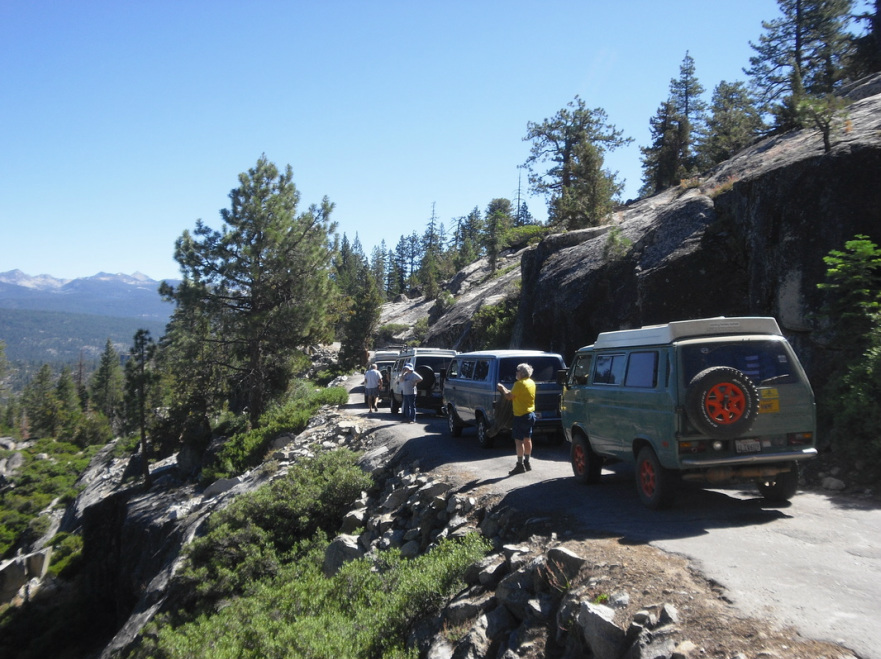
Challenging route. Syncros dropped off along the way. Amazing that Syncros made it up the rock ledges where we turned around. Placed a geocache. Write more stuff here! Tom turned back first, then Sue stopped, then Ed & Bonnie, then Brian Smith - I think?
The roster included:
By: Jim Davis
Challenging route. Syncros dropped off along the way. Amazing that Syncros made it up the rock ledges where we turned around. Placed a geocache. Write more stuff here! Tom turned back first, then Sue stopped, then Ed & Bonnie, then Brian Smith - I think?
The roster included:
Syncros (6)Jim’s olive drab 87 Syncro GL
Brian’s white ’87 Syncro Westy Steve’s blue ’86 Syncro GL Ed's white '91 Syncro Westy Bill's green '89 Country Homes Dave's silver '91 Country Homes |
Syncro-nuts (13)Jim & Deanne Davis daughters Teagen (13) and Tehya (11), plus friend Kylie (12)
Brian & Beth Smith with son Gregory (9) Steve & Jo Ann Wacker Ed Shaw Bill Langan Dave Jordan Tom Neal caught a ride along for this trip too. |
Here’s some trail information from a published sources:
Excerpted from Massey & Wilson "Backcountry Adventures Northern California"This short trail is one of the most spectacular in the region. Southern California Edison maintains the trail to service its hydroelectric facilities at the Bear Diversion Dam, popular for fishing, picnicking, and camping. It is also the start of a hiking trail along Bear Creek. Anglers can fish for brook, brown, golden, and rainbow trout in the spillway. The trail winds around spectacular granite domes and cliffs dotted with western junipers and Jeffrey pines; it is loose and scrabbly in places, with some moderately steep undulations and short sections of single-lane shelf road. It is suitable for most high-clearance 4WD vehicles.
Special Attractions:
Bear Diversion Dam spillway—a popular spot for picnicking and fishing
Access to the John Muir Wilderness along Bear Creek for hikers and equestrians
Difficulty Rating: 4 of 10
Scenic Rating: 10 of 10
Length: 4.6 miles (out & back)
Time: 1 hours (out & back)
DIFFICULTY RATINGS
[The information below is mostly excerpted from Massey & Wilson's "Backcountry Adventures" book series difficulty ratings so you'll know how to interpret the ratings above. Ratings or 4-5 seem best suited for what might be called "mild to moderate, family friendly 4-wheeling" in a Syncro.]
1 [Graded dirt]
2 High-clearance 4WD preferred, not necessary. These trails are dirt roads, but may have rocks, grades, water crossings, or ruts that make clearance a concern in a normal passenger vehicle.
3 High-clearance 4WDs are preferred, but any high-clearance vehicle is acceptable. Expect a rough road surface; mud and sand are possible but will be easily passable. You may encounter rocks up to 6 inches in diameter, a loose road surface, and shelf roads, though these will be wide enough for passing or will have adequate pull-offs.
4 High-clearance 4WDs are recommended, though most stock SUVs are acceptable. Expect a rough road surface with rocks larger than 6 inches, but there will be a reasonable driving line Patches of mud are possible but can be readily negotiated; sand may be deep and require lower tire pressures. There may be stream crossings up to 12 inches deep, substantial sections of single-lane shelf road, moderate grades, and sections of moderately loose road surface.
5 High-clearance 4WDs are required. These trails have either a rough, rutted surface, rocks up to 9 inches, mud and deep sand that may be impassable for inexperienced drivers, or stream crossings up to 18 inches deep. Certain sections may be steep enough to cause traction problems, and you may encounter very narrow shelf roads with steep drop-offs and tight clearance between rocks or trees.
6 These trails are for experienced four-wheel drivers only. They are potentially dangerous, with large rocks, ruts, or terraces that may need to be negotiated. They may also have stream crossings at least 18 inches deep, involve rapid currents, unstable stream bottoms, or difficult access; steep slopes, loose surfaces, and narrow clearances; or very narrow sections of shelf road with steep drop-offs and potentially challenging road surfaces.
7 through 10 [Not considered for Syncro Safari routes so their descriptions are not depicted here.]
END EXCERPT