
4x4 TRAILS STORIES CAMP SYNCRO PHOTOS SYNCRONAUTS ACTIVITIES RESOURCES
Activities in Death Valley
Tuesday and Thursday were “open” days with no specific group activity planned. We took in some of the sights below.
For Tuesday - Sites near Panamint Springs
Darwin Falls Hike
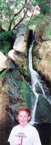
A waterfall in the middle of the arid desert. Named after Dr. Darwin French, Darwin Falls are truly unique and exceptional in every way. The year-round falls provide a water source for plants and wildlife.
This short hike follows one of only four perennial streams in Death Valley National Park, leading through areas of riparian vegetation en route to a spectacular and rare desert waterfall. Darwin Falls is perhaps the most uncharacteristic locale in Death Valley National Park, its setting beyond the scope of most people’s perceptions of the quintessential desert landscape. Darwin Creek is one of the four perennial streams in the park’s more than three-million-acre expanse of desert valleys and mountains. Darwin Wash drains the westernmost reaches of the park, flowing from the volcanic tableland of Darwin Bench between the Inyo Mountains to the north and the Argus Range to the south.
Find the road to the Darwin Falls trailhead about 2 miles west of Panamint Springs on highway 190. From 190 turn left (south) and travel another 2.5 miles on the 2WD dirt road to the parking area marked for Darwin Falls. The hike is about ¾ mile each way and is undeveloped in places and can be “brushy”. Trail crosses small stream several times before reaching the falls.
A real “Oasis” in the desert.
Wildrose Charcoal Kilns
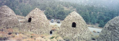
Notice it's SNOWING in the photo and the two Syncros?
In 1877 George Hearst’s Modock Consolidated Mining Company completed construction of the charcoal kilns in Wildrose Canyon. The charcoal produced by the kilns was to be used as fuel for two silver-lead smelters that Hearst had built in the Argus Range 25 miles to the west. The kilns operated until the summer of 1878 when the Argus mines, due to deteriorating ore quality, closed and the furnaces shut down. The Wildrose kilns employed about 40 woodcutters and associated workmen, and the town of Wildrose, a temporary camp located somewhere nearby, was home to about 100 people. Remi Nadeau’s Cerro Gordo Freighting Company hauled the charcoal to the smelters by pack train and wagon.
Each of the 10 kilns stands about 25 feet tall and has a circumference of approximately 30 feet. Each kiln held 42 cords of pinyon pine logs and would, after burning for a week, produce 2,000 bushels of charcoal. Considered to be the best surviving examples of such kilns to be found in the western states, the kilns owe their longevity to fine workmanship and to the fact that they were in use for such a short time.
The Wildrose Charcoal kilns are located in Wildrose Canyon on the western side of Death Valley National Park. Access the Wildrose Canyon road from California Highway 178 between Trona and Panamint Springs.
From Panamnit Springs take California Highway 190 east about 21 miles and take Emigrant Canyon Road south up and over Emigrant Pass about 21 miles and turn left up Wildrose Canyon. The Wildrose Charcoal Kilns are about 7 miles up this road. The last 3 miles of the road are unpaved and the road is subject to storm closures.
Skidoo Ghost Town
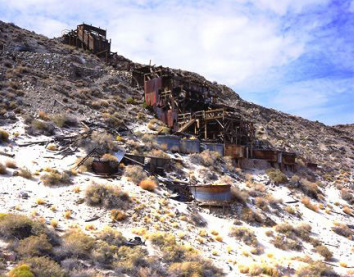
In January 1906 two wandering prospectors, John Ramsey and John (One-Eye) Thompson were headed towards the new gold strike at Harrisburg. Along the way a blinding fog came in and the two camped near Emigrant Spring for fear of getting lost. When the fog lifted they noticed some ledges with promising colors. They filed their claims and kept news of their strike quiet for a couple of months. Bob Montgomery purchased their group of claims entitled the Gold Eagle group. Plans were made that by Jan. 1907. a quartz mill would be installed. Water came from Emigrant Spring, five miles away by trail and seven by wagon. This couldn’t provide enough water for the operation though, so plans were made to acquire the water rights of some springs near Telescope Peak. The water was to flow by gravity pressure from Birch Spring to the mill in a long pipeline ranging from 6-10 inches in diameter. It was estimated to cost $150,000 and fall 1800 feet to generate enough force for mining and milling. It was to be strung in 20-ft. lengths, weighing 650 pounds a length with 18 miles weighing 1544 2/5 tons.
By July 4, 1906, the town seemed assured of success. Plans had already been made for an auto line from Beatty, a stage line seemed definite, application had been made for a post office and with its high altitude (5600 ft.) production could continue all summer. By the end of August 1906 a townsite had been marked out. No one will ever know exactly how the town got its name, 23 Skidoo. Possibilities include the 23 mile water line (which is actually 22 miles long), the 23 claims initially flied, the location of the claim on the 23rd of January, and the 23 men who founded the town.
By March of 1907, Skidoo boasted 400-500 citizens and had stores offering mining equipment, hardware, clothing, dry goods and groceries. There were saloons, a newspaper, restaurants, a physician, and lawyers. By April the town had 130 homes and businesses of frame, wood and iron. A phone line had been completed to Rhyolite, permitting outside communication. In November 1907, the pipeline was finally completed and water flowed into Skidoo. Final tally on the cost was $250,000. The financial panic of 1907 affected the town by reducing plans for additional businesses. By the fall of 1908 mining activity had slowed tremendously in Skidoo due to the scarcity of mills in the area.
Mining activity ebbed and flowed over the next several years and in September 1917, the rich vein was played out and the mine closed down for the last time. By 1922 several buildings were still standing along one street and an old prospector "Old Tom Adams" was the lone citizen. In 1923 Skidoo was one of the location sites for the Hollywood film, "Greed" which was the first feature film made in the Death Valley area.
Skidoo was one of the last gold mining camps in Death Valley. One of the unique features of the mining operation in Skidoo was the mining of large amounts of gold ore by going into narrow ore veins using large-scale mining efforts. The pipeline to Skidoo is considered to be a marvelous feat of engineering. It crossed from Skidoo over Harrisburg Flats and Wood, Nemo, and Wildrose Canyons to the Telescope Peak area.
From Panamnit Springs take California Highway 190 east about 21 miles and take Emigrant Canyon Road south a bit over 9 miles to Skidoo Road. Turn left on the dirt Skidoo Road and travel another 7.5 miles to Skidoo.
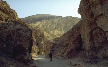
Grotto Canyon Hike
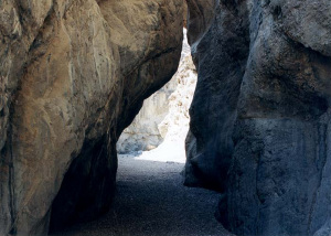
Many canyons slice into the steep, metamorphic rocks that form the slopes of Tucki Mountain, south of Stovepipe Wells in Death Valley National Park, and doubtless all are interesting although most are rather inaccessible and not easily followed. Exceptions are three close to the main highway CA 190 which have a recognized trail at least part of the way: Mosaic, Little Bridge and Grotto, last of which is perhaps the best, and has various graceful narrow sections bordered by polished, twisted, grayish-blue rocks. These tend to end at deep, enclosed passages beneath dryfalls, above which the canyon is temporarily more open, so exploration requires backtracking a way then climbing up the cliffs to bypass the obstruction.
Location: No signpost points the way to Grotto Canyon though its entrance can easily be reached by a rough track that leaves CA 190 to the south, east of Stovepipe Wells Village, and opposite the extended lay-by where people often park to explore and photograph the alluring sand dunes nearby. From Panamint Springs, Stovepipe Wells is about 29 miles east on 190 and the turn-off is another 4 miles beyond Stovepipe Wells. The track is narrow and stony, climbing 500 feet over 2 miles up the large alluvial fan radiating from the canyon mouth, then it drops down into the streambed. All cars should be able to reach the edge of the wash but 4WD vehicles are needed to continue - ahead another mile is drivable, as far as the first enclosed section and dryfall.
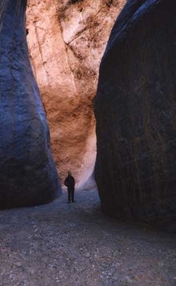
Description: From the parking area at the edge of the wash, the track follows the wash into the gorge, which is at first quite wide, filled with pebbles and shifting gravel. Cliffs gradually rise at either side - made of faded, brown, crumbling rock that supports no plant life, the heat increases as any breeze in the main valley is extinguished, and the general atmosphere becomes quite oppressive. After a few wide bends the canyon constricts quite suddenly, shortly below the first 'grotto' - a cool, sheltered narrow section at the base of a 3-step dryfall, each component being around 10 feet high. 4WD vehicles can drive to within 50 yards of this point, which is said to be a good place for a picnic.
Those with suitable climbing skills may continue directly upstream but an easier option is probably to scramble up a boulder-filled ravine a little way back on the southwest side and then, after climbing quite far, follow a route on the left up to the top of the exposed ridge that separates the ravine from the main canyon, which can then be re-entered by walking back along the ridge and down the slope on the far side where this becomes less steep - joining the wash at a point just above the grotto. The ridge has nice views down to the Stovepipe Wells dunes and up to the continuation of the canyon; not far ahead this seems to disappear into a swirl of tall, colorful rocks.
Back on the streambed, the walk is through an open area for 10 minutes or so and into a second, much longer section of narrows characterized by a clean, flat sandy floor edged by weathered light grey rocks. The cliffs above overhang in a few places creating almost tunnel-like conditions, then further on they rise quite sharply, preceding an impassable dryfall of about 10 yards. This can be overcome by back-tracking again and climbing around on the left side, returning via an easy return route shortly beyond the falls. Another temporary wide part is soon replaced by more lengthy narrows, very beautiful throughout - extensive smooth, bluish-grey, sometimes marble-like channels, worn shiny in places, with occasional small dryfalls, many twists and curves. Eventually the way ahead is blocked by a 12 foot dryfall - maybe free climbable, and certainly negotiable coming back down, but if not then it may be passed by walking back once more about 100 yards and ascending a steep slope on the left, past some large barrel cacti which grow profusely at this elevation, then higher still across the rocky hillside to traverse above some sheer cliffs and finally back down to the wash.
The next narrows start quite soon and are also extensive and pretty, not quite as deep as the previous stretch but with more dryfalls and boulders in the range 3-8 feet, sometimes a little difficult to climb over. I eventually stopped at the base of a smooth 8 foot high pour-off after a walk of about 3 miles from the parking area, and a 1,500 foot elevation gain.
Overall this is an excellent canyon - just testing enough to be interesting, it has a variety of unusual narrow sections, begins after only a short walk from the trailhead and offers the likelihood of complete solitude once past the first grotto.
Location: No signpost points the way to Grotto Canyon though its entrance can easily be reached by a rough track that leaves CA 190 to the south, east of Stovepipe Wells Village, and opposite the extended lay-by where people often park to explore and photograph the alluring sand dunes nearby. From Panamint Springs, Stovepipe Wells is about 29 miles east on 190 and the turn-off is another 4 miles beyond Stovepipe Wells. The track is narrow and stony, climbing 500 feet over 2 miles up the large alluvial fan radiating from the canyon mouth, then it drops down into the streambed. All cars should be able to reach the edge of the wash but 4WD vehicles are needed to continue - ahead another mile is drivable, as far as the first enclosed section and dryfall.
Description: From the parking area at the edge of the wash, the track follows the wash into the gorge, which is at first quite wide, filled with pebbles and shifting gravel. Cliffs gradually rise at either side - made of faded, brown, crumbling rock that supports no plant life, the heat increases as any breeze in the main valley is extinguished, and the general atmosphere becomes quite oppressive. After a few wide bends the canyon constricts quite suddenly, shortly below the first 'grotto' - a cool, sheltered narrow section at the base of a 3-step dryfall, each component being around 10 feet high. 4WD vehicles can drive to within 50 yards of this point, which is said to be a good place for a picnic.
Those with suitable climbing skills may continue directly upstream but an easier option is probably to scramble up a boulder-filled ravine a little way back on the southwest side and then, after climbing quite far, follow a route on the left up to the top of the exposed ridge that separates the ravine from the main canyon, which can then be re-entered by walking back along the ridge and down the slope on the far side where this becomes less steep - joining the wash at a point just above the grotto. The ridge has nice views down to the Stovepipe Wells dunes and up to the continuation of the canyon; not far ahead this seems to disappear into a swirl of tall, colorful rocks.
Back on the streambed, the walk is through an open area for 10 minutes or so and into a second, much longer section of narrows characterized by a clean, flat sandy floor edged by weathered light grey rocks. The cliffs above overhang in a few places creating almost tunnel-like conditions, then further on they rise quite sharply, preceding an impassable dryfall of about 10 yards. This can be overcome by back-tracking again and climbing around on the left side, returning via an easy return route shortly beyond the falls. Another temporary wide part is soon replaced by more lengthy narrows, very beautiful throughout - extensive smooth, bluish-grey, sometimes marble-like channels, worn shiny in places, with occasional small dryfalls, many twists and curves. Eventually the way ahead is blocked by a 12 foot dryfall - maybe free climbable, and certainly negotiable coming back down, but if not then it may be passed by walking back once more about 100 yards and ascending a steep slope on the left, past some large barrel cacti which grow profusely at this elevation, then higher still across the rocky hillside to traverse above some sheer cliffs and finally back down to the wash.
The next narrows start quite soon and are also extensive and pretty, not quite as deep as the previous stretch but with more dryfalls and boulders in the range 3-8 feet, sometimes a little difficult to climb over. I eventually stopped at the base of a smooth 8 foot high pour-off after a walk of about 3 miles from the parking area, and a 1,500 foot elevation gain.
Overall this is an excellent canyon - just testing enough to be interesting, it has a variety of unusual narrow sections, begins after only a short walk from the trailhead and offers the likelihood of complete solitude once past the first grotto.
Telescope Peak Hike (Only for those in great physical condition!)
Length: 14 miles, round trip.
Starting Point: Mahogany Flat Campground, upper Wildrose Canyon Road. Rough, steep road after Charcoal Kilns.
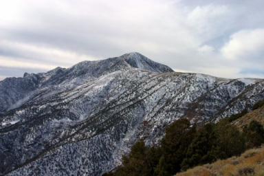
Description: Strenuous trail to highest peak in the park (11,049 ft.) with a 3,000 ft. elevation gain. Ancient bristlecone pines appear just above the 10,000 ft. level. The summit rewards you with spectacular views ranging from Badwater, the lowest point in the Western Hemisphere to the east, to Mt. Whitney, the highest point in the lower 48 United States to the west. Climbing this peak in the winter requires ice axe and crampons, and is only advised for experienced climbers. Telescope Peak is usually snow-free by June. Don't forget that the high altitude may slow you down.
From Panamnit Springs take California Highway 190 east about 21 miles and take Emigrant Canyon Road south up and over Emigrant Pass about 21 miles and turn left up Wildrose Canyon. Pass the Wildrose Charcoal Kilns at about 7 miles up this road. The last 3 miles of the road are unpaved and the road is subject to storm closures. Continue past the kilns another two miles to Mahogany Flat Campground where you’ll find the trailhead.
Starting Point: Mahogany Flat Campground, upper Wildrose Canyon Road. Rough, steep road after Charcoal Kilns.
Description: Strenuous trail to highest peak in the park (11,049 ft.) with a 3,000 ft. elevation gain. Ancient bristlecone pines appear just above the 10,000 ft. level. The summit rewards you with spectacular views ranging from Badwater, the lowest point in the Western Hemisphere to the east, to Mt. Whitney, the highest point in the lower 48 United States to the west. Climbing this peak in the winter requires ice axe and crampons, and is only advised for experienced climbers. Telescope Peak is usually snow-free by June. Don't forget that the high altitude may slow you down.
From Panamnit Springs take California Highway 190 east about 21 miles and take Emigrant Canyon Road south up and over Emigrant Pass about 21 miles and turn left up Wildrose Canyon. Pass the Wildrose Charcoal Kilns at about 7 miles up this road. The last 3 miles of the road are unpaved and the road is subject to storm closures. Continue past the kilns another two miles to Mahogany Flat Campground where you’ll find the trailhead.
Marble Canyon Hike
The road to Cottonwood and Marble Canyons begins just east of the Stovepipe Wells airstrip. This is 30 miles east on 190 from Panamint Springs. The road travels up the broad alluvial fan before reaching the canyon mouth. About 8.0 miles in, the road drops into the wash and becomes rocky and rough. About 1.0 mile past the end of the first narrows, a side road leads up Marble Canyon. At road's end, continue on foot to see some of the finest canyon narrows in the park. There are petroglyphs in the second narrows.
Other possibilities on this side of the park?
Oh, yeah!
- Saline Valley Dunes
- Saline Valley Hot Springs
- Darwin Townsite
- Cerro Gordo 4x4 Trip
- Ballarat Ghost Town
- Trona Pinnacles
- Wildrose Peak Hike
- Cottonwood Canyon
- Harmony Borax Works Interpretive Trail
- Eureka Mine
- Aguereberry Point
- Mosaic Canyon
- Saline Valley Dunes
- Saline Valley Hot Springs
- Darwin Townsite
- Cerro Gordo 4x4 Trip
- Ballarat Ghost Town
- Trona Pinnacles
- Wildrose Peak Hike
- Cottonwood Canyon
- Harmony Borax Works Interpretive Trail
- Eureka Mine
- Aguereberry Point
- Mosaic Canyon
For Thursday - Sites near Furnace Creek
Badwater
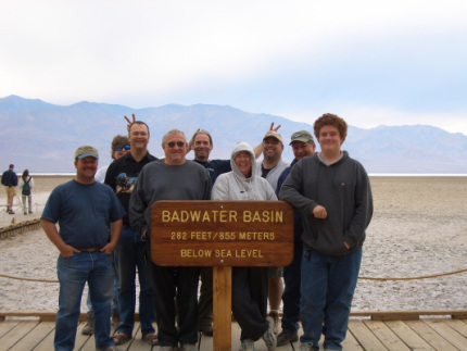
Our group stopped at Badwater on the way to our Warm Springs four-wheeling adventure.
The low, salty pool at Badwater, just beside the main park road is probably the best known and most visited place in Death Valley. The elevation here is 280 feet below sea level. The actual lowest point (-282 feet) is located a couple miles from the road and is not easily accessible - in fact its position varies. An enlarged parking area and other new facilities were constructed in fall 2003 to cope with the ever increasing visitor numbers at the site.
There is not much else to see apart from an orientation table, identifying many of the surrounding mountains. Look up! High in the rocky cliffs above the road, another sign reads 'SEA LEVEL', giving a good indication of just how low the land is. Far above this, the overlook at Dante's Peak has imposing views over Badwater and the surrounding desert.
From the Furnace Creek Campground, travel south on 190 about 1.6 miles and turn right onto Badwater Road. Drive south on Badwater Road about 16.5 miles to the Badwater parking area.
Artists Drive
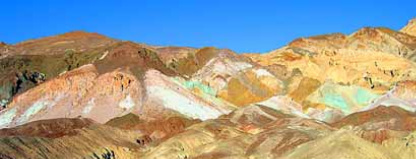
This scenic loop drive shows you the diversity of color that nature has provided with the help of various minerals, oxidation, erosion and of course time. The colors range is purple, green, yellow, white, peach, orange, red, brown, gray, and black. Quite breathtaking, the best time to view this is close to dusk. While traveling the loop you will have a great view of the valley below, as well as the mountain range on the other side. This is a popular place for cyclist, so please keep an eye out for them while traveling. Artists Drive is a 9 mile one-way road with an entrance and exit from Badwater Road.
From the Furnace Creek Campground, travel south on 190 about 1.6 miles and turn right onto Badwater Road. Drive south on Badwater Road about 8.6 miles (passing the Artists Drive EXIT at about 4.8 miles) and turn left into Artists Drive entrance. Enjoy!
From the Furnace Creek Campground, travel south on 190 about 1.6 miles and turn right onto Badwater Road. Drive south on Badwater Road about 8.6 miles (passing the Artists Drive EXIT at about 4.8 miles) and turn left into Artists Drive entrance. Enjoy!
Devil's Golf Course
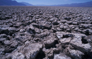
The gnarled terrain of an ancient evaporated lake contains crystals of almost pure table salt. The craggy lake bottom is complex and intricate with crystals in various stages of development. Deposited by ancient salt lakes and shaped by winds and rain, the crystals are forever changing. The Death Valley saltpan is one of the largest saltpans in North America. Salt continues to be deposited by recurring floods that occasionally submerge the lowest parts of the valley floor.
From the Furnace Creek Campground, travel south on 190 about 1.6 miles and turn right onto Badwater Road. Drive south on Badwater Road about 11 miles and turn right and go about 1.7 miles on the dirt road which leads to the “Golf Course”.
From the Furnace Creek Campground, travel south on 190 about 1.6 miles and turn right onto Badwater Road. Drive south on Badwater Road about 11 miles and turn right and go about 1.7 miles on the dirt road which leads to the “Golf Course”.
Natural Bridge Hike
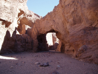
A path leads a quarter mile from the parking area into the canyon. Water rushing through cracks in the weaker strata gradually undercut the rock and left a large natural bridge formation. It now looms 50 feet above the wash. Beyond, part of the canyon wall has been eroded into a grotto.
From the Furnace Creek Campground, travel south on 190 about 1.6 miles and turn right onto Badwater Road. Drive south on Badwater Road about 13 miles and turn left and go about 1.7 miles on the dirt road which leads to the Natural Bridge trailhead.
From the Furnace Creek Campground, travel south on 190 about 1.6 miles and turn right onto Badwater Road. Drive south on Badwater Road about 13 miles and turn left and go about 1.7 miles on the dirt road which leads to the Natural Bridge trailhead.
Dante's View
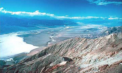
Nearly a mile above Badwater is Dante’s View. From this viewpoint you can nearly see all of Death Valley including the lowest point at Badwater to the highest at Telescope Peak a difference of 11,329 feet. Not much here except the fantastic view, deserving of a "WOW" when first seen.
From the Furnace Creek Campground, travel south on 190 about 10.7 miles and turn right onto Furnace Creek Road. Travel about 7.4 miles and bear right onto Dante’s View Road. Another 5.5 miles brings you to the Dante’s View lookout.
From the Furnace Creek Campground, travel south on 190 about 10.7 miles and turn right onto Furnace Creek Road. Travel about 7.4 miles and bear right onto Dante’s View Road. Another 5.5 miles brings you to the Dante’s View lookout.
Harmony Borax Works
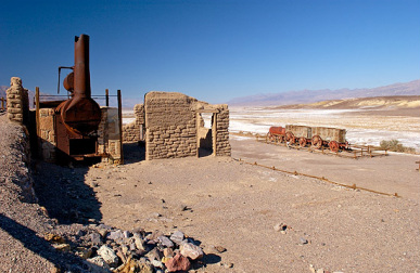
From the Harmony Borax Works, Death Valley's mule teams hauled borax to the railroad town of Mojave, 165 mi away. The teams plied the route until 1889, when the railroad finally arrived in Zabriskie. Constructed in 1883, one of the oldest buildings in Death Valley houses the Borax Museum. Originally a miners' bunkhouse, the building once stood in Twenty Mule Team Canyon. Now it displays mining machinery and historical exhibits. The adjacent structure is the original mule-team barn.
In the Furnace Creek area, borates were deposited in the remains of old lakebeds. Later, partial alteration and solution of these veins by groundwater moved some of the borates to the Death Valley floor where evaporation has left a mixed crust of salt, borates, and alkalies. Aaron Winters found borax on the Death Valley saltpan in 1881. He soon sold his claims to William T. Coleman, builder of the Harmony Borax Works, where borate-bearing muds were refined until 1889.
From the Furnace Creek Campground, travel north on 190 about one mile and turn left to find the Harmony Borax Works.
Golden Canyon Hike
Golden Canyon is a short gorge that cuts into brightly colored sandstone rocks in many glowing shades of orange, gold and red, with the ever-present deep blue sky above making the hues seem especially sharp and intense. Once there was a paved road running up the whole length but this has long been disused and most sections have eroded away. Now, travel on foot is the only option, and the hike is one of the most popular in the national park. Trail guides describing numbered points of interest are available at the nearby parking lot.
The canyon is not particularly enclosed though some of its short tributaries are more narrow. The drainage gains elevation gradually, branches several times then ends quite abruptly after about 1 mile, at the base of high sandstone cliffs - a natural amphitheatre known as Red Cathedral, where the majority of visitors turn back though a longer trail forks south and continues through the multicolored badlands beneath Zabriskie Point, a trip of 4 miles in total. The junction is a few hundred yards south of the cathedral; the path starts by climbing quite steeply up an exposed slope of whitish earth to a high ridge beneath a protruding rock formation, a point which overlooks a wide area of fantastic badlands and canyons.
From the Furnace Creek Campground, travel south on 190 about 1.6 miles and turn right onto Badwater Road. Drive south on Badwater Road about 2 miles and turn left and go up the short road to the Marble Canyon trailhead.
Zabriskie Point
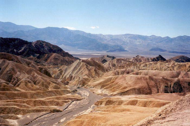
As well as being the title of a curious film by Antonioni (1969), Zabriskie Point is an elevated overlook of a colorful, undulating landscape of gullies and mud hills at the edge of the Funeral Mountains, a few miles from Death Valley - from the viewpoint, the flat salt plains on the valley floor are visible in the distance. In the past it was possible to drive right to the edge of the overlook, and several minutes of the film was set there, but since then a new larger car-park has been constructed lower down and visitors now have a short walk uphill. Most people do little more than briefly admire the scenery, which is best at sunrise, but it is possible to climb some of the adjacent hills to get a better overall view, or wander down amongst the variegated dunes. A foot-path leads through the mounds, down a ravine and into Gower Gulch after 2 miles, while another branch veers right into Golden Canyon.
From the Furnace Creek Campground, travel south on 190 about 3.5 miles and turn right onto short road to the Zabriskie Point lookout.
From the Furnace Creek Campground, travel south on 190 about 3.5 miles and turn right onto short road to the Zabriskie Point lookout.
Furnace Creek Golf Course
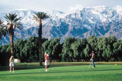
The 18-hole Furnace Creek Golf Course, the world’s lowest golf course at 214 feet below sea level, is an oasis championship course. Originally opened in 1931, the course underwent a major renovation in 1997 by world-renowned golf course architect Perry Dye. Due to the elevation of the course, a slightly greater gravity and barometric pressure force are present. Frequent golfers have noticed a distinct difference in how the ball responds in relation to other courses at or above sea level. Green fees are $55.00 (2005).
From the Furnace Creek Campground, travel south on 190 one-quarter mile. The golf course is on the right.
From the Furnace Creek Campground, travel south on 190 one-quarter mile. The golf course is on the right.
Other activities on this side of the park?
Yes again!
- Borax Museum
- Gower Gulch
- Scotty’s Castle
- Greenwater Valley
- Devil’s Hole
- Death Valley Dunes
- Eagle Borax Works
- Ashford Mill Site
- Shore Line Butte
- Echo Canyon
- Keane Wonder Mine
- Ubehebe Crater
- Saratoga Springs
- Borax Museum
- Gower Gulch
- Scotty’s Castle
- Greenwater Valley
- Devil’s Hole
- Death Valley Dunes
- Eagle Borax Works
- Ashford Mill Site
- Shore Line Butte
- Echo Canyon
- Keane Wonder Mine
- Ubehebe Crater
- Saratoga Springs