
4x4 TRAILS & STORIES PHOTOS CAMP SYNCRO SYNCRONAUTS
Trails & Stories

Monday, Aug 15th - Oceano Dunes SVRA
We aired-down our tires and spent the morning exploring the sand dunes in our Syncros. This is an open area without defined trails and we enjoyed the dues so much three of the Syncros wanted to stay there. Stuck, that is! We did get un-stuck each time though, with plenty of people willing to help when needed.
Since the map had a "Sand Highway" through the dunes, we had naively thought we'd be traveling along a route of compressed sand or hard-pack. Nope. Don't let the term "sand highway" trick you, it turned out to be just a string of posts with not even a hint of defined trail in-between!
We meandered from the north end of the dunes heading south. After a couple of dunes, a couple Syncros decided that this sort of travel just wasn't for them and headed off for other adventures. The remaining Syncros continued on, and quickly Curtis & Sandy Smith's Syncro became stuck. Too bad there was no one around to help them. Actually we had an eager crew swarm over to their van with shovels and a set of "sand ladders" and we had them out in a jiffy. We continued quite a ways over one dune, then another, then anoother stoppping occasionally to survey the best route. We enjoyed having this whole area to ourselves and in a while made it far enough south to turn west and from the edge of the dunes we could see Camp Syncro down on the coast. We continued south for a while more until we were satisfied that each Syncro had sand in every possible crevice. Turning north again, it was impossible to see any sign of where we'd just come as the new tracks dissappear into old ones and both are quickly erased by the wind.
After traveling north a short while, we noticed that we were one Syncro short. We doubled back to see Detlev and Dunia bogged down in the sand. A little digging (the dry sand moves very easily) and they were able to back down a bit and make it up the dune with a little more speed the second try. There are many places to easily get stuck out here and the steepness of the dunes can be tricky to judge because the monochromatic landscape throws off one's depth perception. So much so, that at one point I couldn't see the best way to proceed - even over terrain that we'd already come through about an hour earlier. I decided that the dune on my left looked like the best approach and started down one dune to go up the next. As I got the the bottom of the valley and saw the dune from the bottom I was quickly able to see it was much steeper than I'd thought! I floored the gas pedal but only made it about third of the way up the dune, then quickly shifting into reverse, my only hope was to make it back down and up the other dune. Not even close! I was basically stuck at the bottom of the valley. Now, the weather was nice, and there was plently of help, but still I knew I might be in deep, deep, trouble.
You see it was about 11:30 and I'd promised certain girls (OK, Deanne, Helena & Tehya) back at Camp Syncro that I'd be back by noon to take them to lunch at a fun train-car restaurant in town. This situation had the potential to take a while. Steve Wacker was with me and we were quite a ways from the other Syncros. We got out the shovel and the sand ladders and started digging. It didn't take very long for a crew of helpful Syncronauts to arrive on the scene though. Although they were smart enough to not bring their Syncros down here. We made a sand ramp in front of each front tire, and ramps with the sand ladders in front of the rear tires and discussed strategy. "Go mostly straight." "No, go a little straight, then left." "No, you need to go a little left right away, then to the right." That sort of thing. I knew that the sand ladders would get me about 5 or 6 feet forward, but then what? Stuck again, or would I be able to keep moving? If I got stuck again, I could move the ladders and repeat the process about 100 times to get up the hill 5 feet at a time, taking hours and breaking my lunch promise!
Well, I gave it the gas, went a little straight and a little right and was fortunate enough to power over the sand ladders and keep going all the way up the hill. Once started, there was no way I could risk stopping until I was at the top. So there I was at the top of the dune with my Syncro and the helpful pit crew at the bottom of the hill, left to carry my sand ladders. It's great to have such good friends! The disaster was averted and we made it back to Camp Syncro in time for my lunch date! Lunch was great by the way. Have an onion ring and Check out the Rock N Roll Diner at http://www.beachcalifornia.com/margies-rocknroll-diner-train.html
Other activities available in the area:
Rent an ATV and explore the dunes with some speed!
http://www.bjsatvrentals.com/
Horseback riding in a quiet beach/dune area away form ATVs
http://www.caladventures.com/jjriding.htm
Hide a Syncrocache
http://groups.yahoo.com/group/Syncrocaching/
Biking, hiking, bird-watching, check out Pismo Beach
Boogie-boarding, Surfing
Tuesday, Aug 16th while en route to Big Sur area
GoWesty Tour
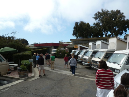
Our group stopped at GoWesty in Los Osos and enjoyed a tour and continental breakfast. Our host, Taylor Grant was very accommodating and took us around to show us their shops, their inventory, their half-wrecked Westys, their store and more. It was very fascinating and then we were treated to a fabulous buffet of fruits and pastires, coffee and more. I think most of us had alread had breakfast, but somehow we managed to consume a table-ful of delicious food! A couple Syncronauts took the opportunity to have their vans looked at by a GoWesty technician, one needing just a minor item, but another, Steve Wacker's Syncro was making odd sounds from the Subaru engine.
GoWesty technicians quickly delivered the bad news, that Steve's cranckshaft pulley was loose from the crankshaft and the prognosis that this could need a minor tightening, a pully replacement or even a crankshaft replacement! More work would need to be done to determine how severe the issue was. Steve would not be able to continue on with the group. Sadly we left him behind as he began making arrangements with another nearby shop that does Subaru work to make a more thorough inspection. Steve even made sure we had the desserts he'd brought for Tuesday Taco Night. Don't stop reading here though, there's more to this story below!
Morro Bay and Morro Rock
After leaving GoWesty we visited the quaint seaside town of Morro Bay and attempted group photos with Morro Rock. We ended up getting split into two groups and Morro Rock was stuck behind a cloud! Lunch and a stroll in Morro Bay was nice.
Morro Bay State Park
http://www.parks.ca.gov/?page_id=594
Hearst Castle at San Simeon
Some of our group stopped and took a tour of Hearst Castle. It's amazing how much this place looks just like my house!
Visit and take a tour. In 2011: Adults: $24, Kids 6-17: $12. See:
http://www.hearstcastle.org
Other activities available in the area include a visit to the quaint town of Cambria.
Taco Night
A Syncro Safari tradition on Tuesday night is the "Taco Night" group dinner:
http://tinyurl.com/5v4752u
Big Sur Area, August 17th to19th
San Martin Top and South Coast Ridge Road
Wednesday, August 17th
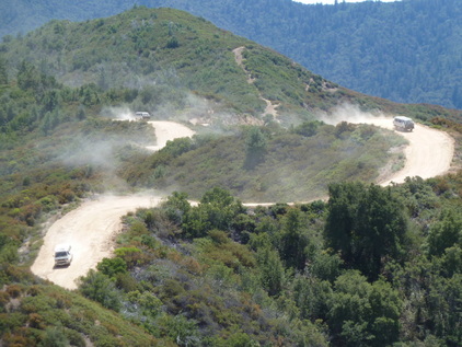
We took a very mild 4WD trip in the coastal mountains to San Martin Top and then along the Coast Ridge Road. This route is mostly rated as a 1 on the difficulty scale with a section leading to San Martin Top as a level 3. Scenic rating according to the So Cal Backcountry Adventures (Massey & Wilson) is an 8.
From our Camp at Plaskett Creek we headed through the morning mist south on Highway 1 just a few miles to Los Burros Road which for some reason is also called Willow Creek Road. Turning inland the road gains elevation quickly and is easy, but dusty travel. After a few miles we rose above the coastal clouds and the sky is clear and blue. About six miles from the highway, we took the spur road to the right which lead to San Martin Top, known for a beautiful view of the coastline below. Along this spur, the terrain gets a bit rougher, but nothing actually difficult - perhaps fit for 2WD even. We found the end of the accessible road with gate and a very small, rough trail that led further downhill and west. There was some deliberation about whether we'd actually reached San Martin Top or not, but we'd certainly gone as far as we could legallly drive. Here, we placed a Syncrocache of goodies. Check out www.Syncrocaching.org and join the Syncrocaching Yahoo Group, or simply head out there and find this Syncrocache at N35 deg 52.388 minutes x E 121deg 25.146 minutes.
After returning back to the Los Burros Road we traveled east another mile and a half and turned north on the Coast Ridge Road. As the name implies, this route more or less follows the ridge of the mountains in a north-south orientation. At this point the day was heating up and it felt like we were an eternity form the cool coast. We eventually found a nice shady spot for lunch and took our time eating and socializing under the trees. Continuing north, we made a decision that we would not visit the Mission San Antonio de Padua today as most of our day had been used up already and some were longing for some beach or nap time back at Plaskett Creek. After nearly 15 miles along the ridge route from Los Burros Road we turned west on Nacimiento-Fergusson Road and took the beautiful paved drive 7 miles back to Highway 1, then south to Camp Syncro.
Yay! We found Steve Wacker at Camp Syncro when we arrived. It turned out that the pulley was able to be replaced and Steve was on his way again, able to rejoin us at Plaskett Creek. We were very happy the issue was not something catastrophic and that Steve could be part of our group again.
Wednesday, August 17th
We took a very mild 4WD trip in the coastal mountains to San Martin Top and then along the Coast Ridge Road. This route is mostly rated as a 1 on the difficulty scale with a section leading to San Martin Top as a level 3. Scenic rating according to the So Cal Backcountry Adventures (Massey & Wilson) is an 8.
From our Camp at Plaskett Creek we headed through the morning mist south on Highway 1 just a few miles to Los Burros Road which for some reason is also called Willow Creek Road. Turning inland the road gains elevation quickly and is easy, but dusty travel. After a few miles we rose above the coastal clouds and the sky is clear and blue. About six miles from the highway, we took the spur road to the right which lead to San Martin Top, known for a beautiful view of the coastline below. Along this spur, the terrain gets a bit rougher, but nothing actually difficult - perhaps fit for 2WD even. We found the end of the accessible road with gate and a very small, rough trail that led further downhill and west. There was some deliberation about whether we'd actually reached San Martin Top or not, but we'd certainly gone as far as we could legallly drive. Here, we placed a Syncrocache of goodies. Check out www.Syncrocaching.org and join the Syncrocaching Yahoo Group, or simply head out there and find this Syncrocache at N35 deg 52.388 minutes x E 121deg 25.146 minutes.
After returning back to the Los Burros Road we traveled east another mile and a half and turned north on the Coast Ridge Road. As the name implies, this route more or less follows the ridge of the mountains in a north-south orientation. At this point the day was heating up and it felt like we were an eternity form the cool coast. We eventually found a nice shady spot for lunch and took our time eating and socializing under the trees. Continuing north, we made a decision that we would not visit the Mission San Antonio de Padua today as most of our day had been used up already and some were longing for some beach or nap time back at Plaskett Creek. After nearly 15 miles along the ridge route from Los Burros Road we turned west on Nacimiento-Fergusson Road and took the beautiful paved drive 7 miles back to Highway 1, then south to Camp Syncro.
Yay! We found Steve Wacker at Camp Syncro when we arrived. It turned out that the pulley was able to be replaced and Steve was on his way again, able to rejoin us at Plaskett Creek. We were very happy the issue was not something catastrophic and that Steve could be part of our group again.
McWay Falls
Thursday, August 19th
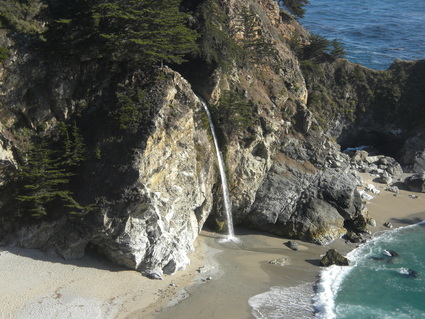
McWay Falls at Julia Pfeiffer-Burns State Park. Photo by Curtis Smith.
At Julia Pfeiffer-Burns State Park there is a fabulous waterfall which falls from the coastal cliffs onto the beach sand below.
Beach waterfall at Julia Pfeiffer-Burns State Park
http://www.parks.ca.gov/?page_id=578
Our group made a stop here, paid the parking fee, and took the short walk to the falls ovelook and beyond to the site where Julia Pfeiffer once lived on this coast. It was a cloudy morning and most of our pictures qualified more for the Digital Scavenger Hunt "Best Photo of Fog" category, than a photo of the fallls. We have Curtis Smith to thank for returning while it was sunny and getting some photos which really show the fall's beauty.
Pfeiffer Beach
Thursday, August 19th

This spot is not easy to find, but persist and you'll be rewarded.
Just a bit south (1 mile) of the entrance to Pfeiffer Big Sur State Park, take Sycaomore Canyon road to the west. There's only a little sign at the highway to help you spot the road, so look closely. Once you start down the road there's a very large stone and concrete sign indicating you're on the right track, but if you don't notice that you might find yourself wondering if you're in the right place, since this tree-lined canyon road doesn't appear to be going to the beach. A little over two miles from the highway, you'll find a fee station (surprise), a parking lot, and bathrooms. Bring your jacket and take the short walking trail to the beach and discover looming rocks in the surf with several holes through them where the breakers come crashing through. On the near sides of the rocks are tidepools where you can find anemones, sea stars and other creatures. This is a really cool spot and our intrepid group of Syncronauts spent our lunchtime here on August 19th.
Pfeiffer Beach, tide pools
http://tinyurl.com/695xjve
The Old Coast Road
Thursday, August 19th

After lunch we continued north on Highway 1 through "downtown" Big Sur heading toward a little more time on the dirt on a road called "The Old Coast Road."
About 4.5 miles north of the entrance to Pfeiffer Big Sur State Park, take the Coast Road to the right. It will begin climbing through the open chaparral covered hills, and frankly at this point the road isn't very intriguing. Continue on and you’ll see what this trek holds. After going over the ridge you’ll descend into a canyon that’s in a whole different world. There are redwoods, ferns, and mosses of every sort as the road winds through the canyon along the small creek. We searched a bit for the elusive banana slug, but found none - unsure if their habitat extends this far south. A very beautiful place, but there’s so much green beauty all around it’s a bit hard to capture in a photo. We tried anyway.
After about 10 miles from the highway, veer left at the junction and you'll descend back toward Highway 1 again,q where you find the very picturesque Bixby Bridge. We'd hoped to get a photo of Syncros on the bridge, but being pressed for time and finding no way to shut down the highway for our photo-op we had to pass.
Other attractions along the Big Sur Coast
Sand Dollar Beach - right across Hwy 1 from Plaskett Creek Campground, this beach is fabulous! It includes rocks to climb on, smooth sandy beach, tidepools and even sea caves to check out. Oddly there were almost no sand dollars, but wer did find sea stars and other creatures. Fun for mild boogie-boarding, and maybe surfing.
Point Sur Lighthouse - if you take the Old Coast Road from south to north, you can make a loop trip by taking Highway 1 south and you'll find the Point Sur Lighthouse. It has limitied visitors hours , so inquire ahead.
http://www.pointsur.org/
Mission San Antonio de Padua (the most remote, least visited mission in the pacific chain)
Our group considered a trip to this mission, but decided to head back to the beach instead. Check this out:
http://www.missionsanantonio.net
Monterey, Santa Cruz and Half Moon Bay, August 19 - 21

Friday, August 19th while en route to Half Moon Bay
Monterey Bay Aquarium
http://www.montereybayaquarium.org/
Famous "17 Mile Drive" on the Monterey Peninsula
http://www.seemonterey.com/17-mile-drive
Castroville - Artichoke capital of the world :-)
Van Cafe in Santa Cruz.
http://www.van-cafe.com/
Santa Cruz Boardwalk
http://www.beachboardwalk.com/
Big Basin Redwoods State Park (CA's oldest State Park)
http://bigbasin.org/
Biking (there's a long bike path that goes for miles through this area)
Rent Sea kayaks and explore the coast
http://www.hmbkayak.com