
|
A desert adventure across America's most remote desert region.
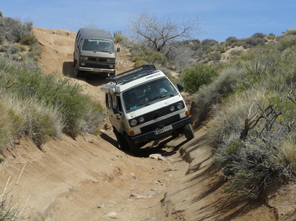
We experienced what it might have been like to traverse the Mojave in the moccasins of explorer Jedediah Strong Smith in 1826. Our expedition took in all 140+ miles of the Mojave Road from the banks of the Colorado River in Nevada to Camp Cady, and then some... |
|
Trip Overview
Mojave Road '14 was a springtime event taking advantage of the nice spring weather in the Mojave Desert. The dates were Sunday, April 6th through Saturday, April 12th. The venue was the 140+ mile trek along the historic Mojave Road. While some have done the Mojave Road in just 2-3 days or even at racing pace in a single day, our adventure included five days traversing this route. This allowed us a relaxed schedule and the opportunity to see all the most significant sites along the route. We spent four of the five days travelling along the route, allowing one relaxing day without travel at the Desert Studies Center at Zzyzx for sight-seeing, hiking, bird-watching, swimming, “wildflowering”, and photography.
Mojave Road '14 was a springtime event taking advantage of the nice spring weather in the Mojave Desert. The dates were Sunday, April 6th through Saturday, April 12th. The venue was the 140+ mile trek along the historic Mojave Road. While some have done the Mojave Road in just 2-3 days or even at racing pace in a single day, our adventure included five days traversing this route. This allowed us a relaxed schedule and the opportunity to see all the most significant sites along the route. We spent four of the five days travelling along the route, allowing one relaxing day without travel at the Desert Studies Center at Zzyzx for sight-seeing, hiking, bird-watching, swimming, “wildflowering”, and photography.
|
|
Mojave Road? What’s that? Why would you want to go there?
So, if you’ve read this far, you either already know something about the Mojave Road, or you’d like to know why we picked this route. Here’s a little overview…
Long before the first white man saw the Mojave Desert region an ancient trade route crossed the Eastern Mojave. It connected the tribes of the Mojave Indians with other tribes to the west and ultimately to the California coast. This significant Indian trade route was first used by someone from the “old world” when Spaniard explorer and missionary Francisco Garces traversed it in 1776 on his way to find the Mission San Gabriel. The next famous traveler on the route was Jedidiah Strong Smith in 1826. Other early travelers included John Charles Fremont and Kit Carson. In the mid 1800’s a mail route was needed for the US government, and the area was surveyed (using imported camels!) and eventually outposts and forts were set up along the route to safeguard the mail. Later, mining and cattle enterprises dotted the Mojave, all using this important east-west route. Eventually a railroad and more modern highways were established along different routes and the Mojave Road was nearly lost for good. That is until the 1970’s, when Dennis Casebier investigated the route and first published a book on the subject. In the early 1980’s a group known as “Friends of the Mojave Road” formed and dedicated themselves to reopening the route for recreational, educational, and inspirational purposes. The latest editions of Casebier’s “Mojave Road Guide” now include GPS coordinates and clear directions and maps to follow, making access to the special, scenic, and historic spots along the route more accessible than ever.
While a number of Syncros have traversed the route (or at least parts of it) in the past, we think this adventure was the most complete, educational, and enjoyable Mojave Road trip ever. The number of historic sites, interesting geology, scenic desert vistas, sand dunes, volcanic craters, petroglyphs, and interesting canyons and formations is simply too many to list here. There are literally a couple of book series, each with at least two volumes about interesting sites in this region.
Itinerary Overview:
Sunday, April 6th: Gathered and camped at Big Bend of the Colorado State Park in Nevada, south of Laughlin. We had time to enjoy a little swimming in the very cold river water. We arranged with the park management to allow our group to camp in the day-use area right along the water's edge! This site is literally right on the Colorado River as there was just sand between the Syncros and the water.
Monday, April 7th: We traveled a short distance south along the Colorado River to “Mile 0” (487 feet elevation) where early travelers crossed the river. From here, our westward trek took us to a number of sites along the way including Fort Piute. Then we turned south, departing the Mojave Road, for a detour to Goffs. We stayed Monday night there at Goffs Cultural Center and were treated to a presentation on the Mojave Road history by author (The Mojave Road Guide) and expert Dennis Casebier. Our traditional Taco Night was held at Goffs and included Dennis and also Hugh and Carol Brown from the Mojave Desert Heritage and Cultural Association, plus author (California Serendipity) Andy Cohrs. Accommodations at Goffs included very friendly and gracious hosts, flush toilets and showers! 69 miles of travel this day.
Tuesday, April 8th: We traveled north back to the Mojave Road and after a bit of "directional confusion" continued west to visit Rock Springs , and then again detoured from the Mojave Road to visit the unique rock formations and hiked the “Ring Trail” at Hole In The Wall where there are iron rings placed into the rock to help your descent and ascent through this narrow canyon. We took Wild Horse Canyon Road north to Mid Hills Campground where we stayed among Pinion Pines and Junipers between the Providence Mountains and the New York Mountains at an elevation of 5,600 feet. 51 miles of travel this day.
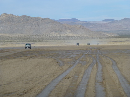
Wednesday, April 9th: Continued our expedition westward descending out of the mountains to Marl Springs, and took a side trip to walk through the underground Lava Tube - really an amazing and fun site. Then crossed dry Soda Lake. Happy to report it lived up to its dry name when we traversed it. Recent storms can sometimes make this section impassible as a few previous Syncronauts have found. On the west side of the lake, we found our destination, the Desert Science Center at Zzyzx. We camped at the center and had use of their facilities, including showers and watched screening of “The Bus Movie” with facility manager Rob Fulton who once had a 1964 Splittie! 61 miles of travel this day.
Thursday, April 10th: We were treated to a tour of the Desert Science Center facility and in the evening an educational session on desert wildlife by Rob. The balance of Thursday was open for recreation and relaxation where we enjoyed use of the facility's swimming pool and spent a second night at the DSC. We also made the 24 mile round-trip into Baker and back for fuel and lunch at the Mad Greek. After Rob's presentation on desert wildlife, we geared up with ultraviolet flashlights and went on a Scorpion Photo Hunt - we found many!!
Friday, April 11th: Our trek continued westward across the Rasor Off Highway Vehicle area and up the Mojave River wash through scenic Afton Canyon. We took an amazing hike in a slot canyon called “Spooky Canyon” (flashlights required believe it or not) and made two water crossings of the Mojave River and saw other Afton Canyon sites. Continued to the western terminus of the Mojave Road Recreation Trail at the historic Camp Cady site (Mile 140), about 40 miles from the morning’s start. Wow, the ruins of the old Camp Cady were not easy to find. From there we travelled northwest out of the Mojave River area, and camped at Owl Canyon Campground in the scenic Rainbow Basin loop road area. 76 miles of travel this day.
Saturday, April 12th: The adventure's over, said our goodbyes and parted ways to head home.
Additional Activities and Information:
Monday Taco Night!
For all other meals, we each provided for ourselves, but for Monday's "Taco Night" we coordinated our efforts and created a fun Taco Fiesta dinner to share - including guests from the Mojave Desert Heritage & Cultural Center. Delicious, with plenty of desserts too!
Guest Speakers!
We were so fortunate to have three expert guest speakers during our adventure. Monday evening, Mojave Desert expert and author Dennis Casebier provided a presentation on the history of the Mojave Road at Goffs. Tuesday morning, Mojave Desert Heritage and Cultural Association director Hugh Brown provided a tour of the facility and we were able to see many collected examples of Mojave Desert history. Wednesday evening Rob Fulton, Manager of the Desert Studies Center, provided an educational presentation on Desert Wildlife. Rob continued on Thursday morning with a tour of the DSC and more education on local desert life including the Mojave Chub, a small fish inhabiting the facility's pond.
Digital Photo Scavenger Hunts!
The "digital photo scavenger hunt" has been a perennial favorite of Syncro Safari! We included the hunts again this year where Syncronaut teams get lists of particular items to photograph. Each Syncro's team tracked down these sites or people or activities and took digital pictures. Back at camp, we shared the photos and see who snapped what. The teams with the most matching photos each round won the AAA award. Appreciation, Applause and Accolades and a real prize too!
Further Information:
Here are some websites with information that may be useful in helping you plan a similar adventure.
Big Bend of the Colorado State Park in Nevada
The Mojave National Preserve NPS website
The Mojave Road page at the NPS website
The Mohave Desert Heritage and Cultural Association (MDHCA)
Mid Hills Campground
A Mojave Road Informational website
Lava Tubes site
The Desert Studies Center
The Rainbow Basin and Owl Canyon
A Mojave Road Trip Report on Expedition Portal
The premier book on the topic of the Mojave Road is the Mojave Road Guide.
I’ve been using it extensively for planning this trip.
Here are some Google photo searches on these topics too:
Afton Canyon
Spooky Canyon
Mojave Petroglyphs
Soda Lake
Ring Trail
Sunday, April 6th: Gathered and camped at Big Bend of the Colorado State Park in Nevada, south of Laughlin. We had time to enjoy a little swimming in the very cold river water. We arranged with the park management to allow our group to camp in the day-use area right along the water's edge! This site is literally right on the Colorado River as there was just sand between the Syncros and the water.
Monday, April 7th: We traveled a short distance south along the Colorado River to “Mile 0” (487 feet elevation) where early travelers crossed the river. From here, our westward trek took us to a number of sites along the way including Fort Piute. Then we turned south, departing the Mojave Road, for a detour to Goffs. We stayed Monday night there at Goffs Cultural Center and were treated to a presentation on the Mojave Road history by author (The Mojave Road Guide) and expert Dennis Casebier. Our traditional Taco Night was held at Goffs and included Dennis and also Hugh and Carol Brown from the Mojave Desert Heritage and Cultural Association, plus author (California Serendipity) Andy Cohrs. Accommodations at Goffs included very friendly and gracious hosts, flush toilets and showers! 69 miles of travel this day.
Tuesday, April 8th: We traveled north back to the Mojave Road and after a bit of "directional confusion" continued west to visit Rock Springs , and then again detoured from the Mojave Road to visit the unique rock formations and hiked the “Ring Trail” at Hole In The Wall where there are iron rings placed into the rock to help your descent and ascent through this narrow canyon. We took Wild Horse Canyon Road north to Mid Hills Campground where we stayed among Pinion Pines and Junipers between the Providence Mountains and the New York Mountains at an elevation of 5,600 feet. 51 miles of travel this day.
Wednesday, April 9th: Continued our expedition westward descending out of the mountains to Marl Springs, and took a side trip to walk through the underground Lava Tube - really an amazing and fun site. Then crossed dry Soda Lake. Happy to report it lived up to its dry name when we traversed it. Recent storms can sometimes make this section impassible as a few previous Syncronauts have found. On the west side of the lake, we found our destination, the Desert Science Center at Zzyzx. We camped at the center and had use of their facilities, including showers and watched screening of “The Bus Movie” with facility manager Rob Fulton who once had a 1964 Splittie! 61 miles of travel this day.
Thursday, April 10th: We were treated to a tour of the Desert Science Center facility and in the evening an educational session on desert wildlife by Rob. The balance of Thursday was open for recreation and relaxation where we enjoyed use of the facility's swimming pool and spent a second night at the DSC. We also made the 24 mile round-trip into Baker and back for fuel and lunch at the Mad Greek. After Rob's presentation on desert wildlife, we geared up with ultraviolet flashlights and went on a Scorpion Photo Hunt - we found many!!
Friday, April 11th: Our trek continued westward across the Rasor Off Highway Vehicle area and up the Mojave River wash through scenic Afton Canyon. We took an amazing hike in a slot canyon called “Spooky Canyon” (flashlights required believe it or not) and made two water crossings of the Mojave River and saw other Afton Canyon sites. Continued to the western terminus of the Mojave Road Recreation Trail at the historic Camp Cady site (Mile 140), about 40 miles from the morning’s start. Wow, the ruins of the old Camp Cady were not easy to find. From there we travelled northwest out of the Mojave River area, and camped at Owl Canyon Campground in the scenic Rainbow Basin loop road area. 76 miles of travel this day.
Saturday, April 12th: The adventure's over, said our goodbyes and parted ways to head home.
Additional Activities and Information:
Monday Taco Night!
For all other meals, we each provided for ourselves, but for Monday's "Taco Night" we coordinated our efforts and created a fun Taco Fiesta dinner to share - including guests from the Mojave Desert Heritage & Cultural Center. Delicious, with plenty of desserts too!
Guest Speakers!
We were so fortunate to have three expert guest speakers during our adventure. Monday evening, Mojave Desert expert and author Dennis Casebier provided a presentation on the history of the Mojave Road at Goffs. Tuesday morning, Mojave Desert Heritage and Cultural Association director Hugh Brown provided a tour of the facility and we were able to see many collected examples of Mojave Desert history. Wednesday evening Rob Fulton, Manager of the Desert Studies Center, provided an educational presentation on Desert Wildlife. Rob continued on Thursday morning with a tour of the DSC and more education on local desert life including the Mojave Chub, a small fish inhabiting the facility's pond.
Digital Photo Scavenger Hunts!
The "digital photo scavenger hunt" has been a perennial favorite of Syncro Safari! We included the hunts again this year where Syncronaut teams get lists of particular items to photograph. Each Syncro's team tracked down these sites or people or activities and took digital pictures. Back at camp, we shared the photos and see who snapped what. The teams with the most matching photos each round won the AAA award. Appreciation, Applause and Accolades and a real prize too!
Further Information:
Here are some websites with information that may be useful in helping you plan a similar adventure.
Big Bend of the Colorado State Park in Nevada
The Mojave National Preserve NPS website
The Mojave Road page at the NPS website
The Mohave Desert Heritage and Cultural Association (MDHCA)
Mid Hills Campground
A Mojave Road Informational website
Lava Tubes site
The Desert Studies Center
The Rainbow Basin and Owl Canyon
A Mojave Road Trip Report on Expedition Portal
The premier book on the topic of the Mojave Road is the Mojave Road Guide.
I’ve been using it extensively for planning this trip.
Here are some Google photo searches on these topics too:
Afton Canyon
Spooky Canyon
Mojave Petroglyphs
Soda Lake
Ring Trail

|
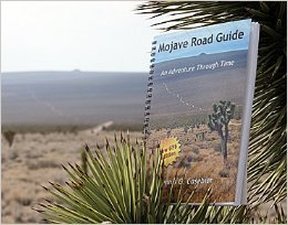
Planning a trip on the Mojave Road? BUY THIS BOOK!
at Mojave Desert Heritage & Cultural Association or Amazon |