
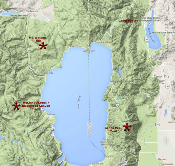
4x4 TrailsAt Syncro Safari, Tahoe '15 took remote Syncro adventures on three (Monday, Wednesday, and Friday) of our days together. Trails were selected for heir scenery, historic value, and for a mild-moderate 4-wheeling challenge.
We had a few challenges on the trails but nothing to damage our Syncros. We all got back in one piece. Scenery, especially views of Lake Tahoe, was breathtaking! |
|
Monday, July 13 - Genoa Peak Trail
Excerpted from www.Trails.com:
"This trail begins just off of Nevada 207 near Lake Tahoe. Proceed north off the highway on North Benjamin Drive. This paved road accesses the National Forest road after running through a residential area for approximately 2 miles. Before entering the National Forest, the paved road becomes Andrea Drive. Passing through a seasonal gate into the USFS Lake Tahoe Basin Management Unit, the dirt road is one lane wide, but with plenty of pullouts for passing oncoming vehicles. Proceeding north, the trail runs through a forest of mainly conifers trees. Large embedded rocks make it a bumpy ride, and large boulders flank the road on either side. Special Attractions: Views of Lake Tahoe. Network of 4WD roads to explore. Good picnic spots."
Wednesday, July 15 - Mount Watson Trail
Excerpted from the fantastic guide book "Backcountry Adventures, Northern California" by Peter Massey and Jeanne Wilson.
"Mount Watson Trail begins in Tahoe City at the headwaters of the Truckee River, the only outlet from Lake Tahoe. California 89 crosses the Truckee River at this point on the Virginia Street bridge, a landmark of some renown. In 1906, the dissatisfied spouse of a leading national businessman came to Reno, Nevada, to annul her marriage. The high-profile divorce made Reno the place to get separated with panache. The final statement for such a dissolution was to travel up to Tahoe City and cast the now defunct wedding ring off the side of the Virginia Street Bridge. This ring-throwing ceremony was immortalized by Marilyn Monroe in her last movie, The Misfits.
This route, also known as the Fiberboard Freeway, mainly follows a series od developed logging roads. Most of the trail is rated a 2 for difficulty; the 3 rating comes from the section leading out of Tahoe City. This small, formed trail can be loose and steep enough to require four-wheel-drive; this section is seasonally closed to motor vehicles to protect the trail surface.
The trail winds through Tahoe National Forest, passing a mix of aspens and conifers and offering many opportunities for hiking or camping along the way. A short spur leads to a small clearing at the top of Mt. Watson, which provides fantastic views of Lake Tahoe. A second short spur leads to Watson Lake, which is a good place to camp or picnic. The banks of the lake are fringed with wildflowers in spring. It is normally quiet and sees little of the crowds that visit Lake Tahoe. The Western States Trail, part of the American Discovery Trail, and the Tevis Cup Trail both follow part of the Mount Watson route along the ridge.
Past the spur to Watson Lake, the trail follows better graded roads below Sawtooth Ridge, descending gradually toward Truckee. To the west is Squaw Valley, one of the region’s popular ski areas.
Starting Point: California 89 in Tahoe City, 0.2 miles southwest of the intersection with California 28
Finishing Point: California 267, 0.4 miles south of Truckee
Total Mileage: 20.8 miles, plus 1.5 mile spur to Mount Watson and a 0.9 mile spur to Watson Lake
Unpaved Mileage: 13.7 miles, plus spurs
Driving Time: 1.5 hours
Elevation Range: 5,900 – 8,200 feet
Usually Open: July to October
Best Time to Travel: Dry weather
Difficulty Rating: 3
Scenic Rating: 8
Remoteness Rating: +0 "
* Note: See difficulty descriptions below.
Friday, July 17 - McKinney Creek Trail ("A Taste of the Rubicon")
Excerpted from the fantastic guide book "Backcountry Adventures, Northern California" by Peter Massey and Jeanne Wilson.
McKinney Creel Trail
"McKinney Creek Trail follows a short section of the infamous Rubicon Trail, a hardcore jeep trail for modified vehicles, before heading north to Barker Pass.
The trail leaves from the edge of Tahoma along a small paved road, following signs to the Rubicon OHV Trailhead. Past the trailhead, it becomes a rough dirt trail that has been stabilized with loose crushed rock to help minimize damage to the meadows and marshes. Please do not travel this trail in wet weather. Avoiding the trail when wet will minimize damage and help keep this historic route open.
Along McKinney Creek, the trail is loose in places with a few embedded rocks. The Sierra Nevada fault, a major California fault line, crosses the trail near Lake Tahoe.
The trail passes several lakes: The first two, McKinney Lake and Lilly Lake, are covered with water lilies; the third, Miller Lake, is open water. The lakes were formed when eastbound glaciers dropped moraine, forming natural dams. A few campsites can be found near the lakes.
The trail forks after 5.8 miles. The Rubicon Trail continues to the left on its long journey to Georgetown. A short distance past the intersection, the Rubicon starts to show its colors and becomes 7-rated as it crawls over large boulders. The Rubicon Trail in its entirety is not suitable for stock vehicles. The main trail turns right at this intersection and follows a roughly graded road, climbing toward Barker Pass. The trail passes Bear Lake, which is set below the trail, and the rock bowl of Cothrin Cove. The final part of the route leaves the graded road and winds along the uneven Barker Meadow OHV Trail, passing beside Barker meadow.
The trail copmes to an end at the Pacific Crest National Scenic Trailhead at Barker Pass. The more difficult Blackwood Canyon Trail leaves from Barker Pass and can be combined with McKinney Creek Trail to make a loop back to California 89. For a more direct way back to the highway, turn right onto Barker Pass Road (FR 03), which quickly becomes paved and drops swiftly to join California 89.
Starting Point: California 89 in Tahoma
Finishing Point: FR 03 at Barker Pass
Total Mileage: 11.5 miles
Unpaved Mileage: 9.5 miles
Driving Time: 3 hours
Elevation Range: 6,200 – 7,700 feet
Usually Open: July to November
Best Time to Travel: Dry weather only
Difficulty Rating: 4
Scenic Rating: 8
Remoteness Rating: +0 "
* Note: See difficulty descriptions below.
Trail NOT taken: Blackwood Canyon Trail
(We expected to make a loop of McKinney Creek and Blackwood Canyon, but the going was slow and by the time we got to Miller Lake, we had a nice picnic and headed back. Description included here for those who might want to make this loop in the future.) Description below excerpted from the fantastic guide book "Backcountry Adventures, Northern California" by Peter Massey and Jeanne Wilson.
"This short trail begins along Blackwood Creek and climbs up the ridge to Barker Pass. The route parallels paved Barker Pass Road, but the paved road is not visible from the trail. Compact and subcompact 4WDs are best suited for this trail; extra wide of full size vehicles may not make the squeeze between two trees encountered 2.6 miles from the start of the trail.
The trail gets its difficulty rating from the long, moderately steep, loose climb up a single vehicle width trail. A few embedded rocks must be negotiated along the trail. The hardest pinch is the final 50 yards before the top of the climb. However, a stock, high-clearance 4WD in low range should be able to negotiate the rocks with careful wheel placement.
Good views over Blackwood Canyon and a glimpse of Lake Tahoe make this a very scenic drive. The trail finishes at the Pacific Crest National Scenic Trailhead on Barker Pass. McKinney Creek Trail heads south from Barker Pass, the two can be combined for a longer loop back to California 89.
Starting Point: Barker Pass Road (FR 03), 2.2 miles west of California 89 and Idlewild
Finishing point: m Barker Pass Road (FR 03), opposite McKinney Creek Trail
Total Mileage: 3.6 miles
Unpaved Mileage: 3.6 miles
Driving Time: 45 minutes
Elevation Range: 6,400 – 7,700 feet
Usually Open: July to November
Best Time to Travel: Dry weather
Difficulty Rating: 5
Scenic Rating: 8
Remoteness Rating: +0 "
Trail Ratings
Trails are rated here on a very simple basis and truthfully there’s much more behind describing trail difficulty than this simplification does justice to. But, for the sake of simplicity these ratings are compared to a typical Syncro’s capability. What’s a typical Syncro? Original 2.1L engine, 14” wheels with 27” LT all-terrain tires, and a rear differential lock.
Syncro Safari Ratings
Easy – 2WD with decent tires and maybe a little ground clearance can do this trail.
Mild – Occasional 4WD needed, obstacles are not a real challenge for a Syncro, Diff-lock not needed.
Moderate – 4WD often needed, challenging for a Syncro, Diff-lock needed at times, some obstacles
require getting out, scouting a route, stacking some rocks.
Difficult – 4WD often needed, some obstacles more than a Syncro can handle, Diff-lock often required,
significant terrain modification to make passable for a Syncro, damage likely
Extreme – Fuh-getaboudit! Serious off-road vehicles needed, not passible by a Syncro
The Massey & Wilson trail ratings are included in the fantastic guide book "Backcountry Adventures" series by Peter Massey and Jeanne Wilson.
Rating 1: The trail is graded dirt but suitable for a normal passenger vehicle. It usually has gentle grades, is fairly wide, and has shallow water crossings (if any).
Rating 2: High-clearance vehicles are preferred but not necessary. These trails are dirt roads, but they may have rocks grades, water crossings, or ruts that make clearance a concern in a normal passenger vehicle. The trails are fairly wide, making passing possible at almost any point along the trail. Mud is not a concern under normal weather conditions.
Rating 3: High-clearance 4WDs are preferred, but any high-clearance vehicle is acceptable. Expect a rough road surface; mud and sand are possible but will be easily passable. You may encounter rocks up to 6 inches in diameter, a loose road surface, and shelf roads, though these will be wide enough for passing or will have adequate pull-offs.
Rating 4: High Clearance 4WDs are recommended, though most stock SUVs are acceptable. Expect a rough road surface with rocks over 6 inches, but there will be a reasonable driving line. Available. Patches of mud are possible but can readily be negotiated; sand may be deep and require low tire pressures. There may be stream crossings up to 12 inches deep, substantial sections of single lane shelf road, moderate grades and sections of moderately loose road surface.
Rating 5: High-clearance 4WDs are required. These trails have either a rough, rutted surface, rocks up to 9 inches, mud and deep sand may be impassable for inexperienced drivers, or stream crossings up to 18 inches deep. Certain sections may be steep enough to cause traction problems, a nd you may encounter very narrow shelf roads with steep drop-offs and tight clearance between rocks and trees.