
|
Friday, Aug 18 - Hat Creek Rim Trail North Sierra #46 & 47
Third of three group Syncro trips – Hat Creek Rim Trail and the Murken Bench Trail. This is a full day trip. We’ll visit "Subway Cave", an underground lava tube to explore – bring FLASHLIGHTS and a JACKET. Hang Glider launch and landing spots and plan to take a tour at the SETI (Search for Extra-Terrestrial Intelligence) radio observatory grounds. Time permitting, we’ll continue north to view unique Burney Falls and the “Stand By Me” bridge from famous the movie scene. Before heading back to camp, we’ll pass by the gas station at Old Station again. Trail Description - Excerpted from Backcountry Adventures Northern California. by Peter Massey and Jeanne Wilson Buy this book if you plan to do any exploring in Northern California. It's terrific! Northern Sierra Route #46 Hat Creek Rim Trail Total Mileage: 18.9 miles, plus 1.6 mile spur to the lookout site Driving Time: 3 hours Elevation Range: 3300 - 5000 ft. Difficulty Rating: 1 Scenic Rating: 8 Special Attractions:
|
Syncro design by NRWSTR.com
|
History
The name Hat Creek dates back to the mid-1850s. the name may come from the Achomawi word hatiwiwi, their name for Hat Creek. Another origin may be that a member of William H. Nobles’ emigrant party dropped his hat in the stream.
The route runs close to a cutoff along the Nobles Trail, which ran below present-day California 44. Called the Yreka and Fort Crook Road, it branched due north from the main trail to Lockhart’s Ferry via Government Well and was used by stagecoaches traveling between California and Oregon in 1856.
The Hat Creek Rim Fire Lookout, along the upper reaches of the rim, was destroyed int eh 1987 Lost Fire. Lightning caused the fire and ultimately burned nearly 23,000 acres. All that remains of the old tower is the steel frame base.
One not-to-be-missed feature of this area is a short distance from the start of the trail. Subway Cave, a lava tube, formed less than 20,000 years ago when molten lava flowed out of a series of north-south fissures int eh earth. Surface lava cooled and hardened, but lava below the surface continued to flow, eventually draining away to leave the tube. A marked trail runs through the cave and returns to the parking area aboveground. A reliable flashlight is essential because there is zero visibility inside the cave, and the floor is very rough. The temperature in the cave remains a constant 46 degrees Fahrenheit year-round, so you might want to bring along a jacket. Inside the cave, you can see hardened lava formations, chambers, and burst lava bubbles. Subway Cave is just off California 89, 0.5 miles north of the intersection of California 44 and California 89 at Old Station.
Description
The trail proper leaves California 44, 2.7 miles east of Old Station. The Hat Creek Rim scenic overlook, at the start of the trail, is an interpretive site that provides a panoramic view of the Hat Creek Valley and surrounding volcanic peaks. On a clear day, Mount Shast is clearly visible to the northwest. Mud flows from the 1915 eruption of Lassen Peak poured into the Hat Creek drainage. Snowmelt from Lassen Peak, Big Spring, and Rising River feed the stream, and it is regularly stocked with brook, brown, and rainbow trout in summer. Good fishing can be found near the southern end of the trail at Hat Creek Campground, Old Station Day-use Area, and Cave Campground. The graded road heads north from the scenic overlook, following close to the geological fault of Hat Creek rim. Nearly a million years ago, a block of the Earth’s crust dropped 1000 feet below the rim (hat Creek Valley), leaving behind the fault scarp known as Hat Creek Rim.
The easy trail is generally suitable for passenger vehicles. One small loop near the start leaves the main graded road to travel closer to the rim; this section is rated 2 and is more suitable for high-clearance vehicles. If you do not wish to drive the loop, remain on graded road 34N34 – the loop rejoins in 0.8 miles.
The trail stays back from the rim most of the way, but a spur leads to the site of the old fire lookout tower, now used for communications equipment and as an alternative launch site for hang gliders. This Back Launch was constructed in 1993 and is considered more difficult than the more popular Front Launch further north along the trail. Back Launch should only be used by experienced pilots. The Pacific Crest National Scenic Trail runs past this launch site very close to the rim.
The Front Launch for hang gliders and paragliders is marked partway along the descent to Hat Creek Valley. For non-flyers, this is a wonderful viewpoint and picnic area, with the added bonus that you may be lucky enough to see hang gliders launching from the pad. The site has a reliable updraft in summer and is used from spring through to October. Norther Sierra #47: Murken Bench Trail loops off from the main trail and passes beside two landing sites at the base of the rim.
The road then becomes paved and passes the University of California Hat Creek Radio Observatory. Visitors are welcome on certain days from 9:00 AM to 4:00 PM. The facility houses the UC Berkeley’s Radio Astronomy Laboratory.
The trail ends at a T-intersection with Doty Road, which you can take either way back to California 89.
Northern Sierra Route #47 - Loop Spur from Hat Creek Rim Trail
Murken Bench Trail
Total Mileage: 3 miles
Driving Time: 30 minutes
Elevation Range: 3500 - 3600 ft.
Difficulty Rating: 2
Scenic Rating: 8
Special Attractions:
History
The Atsugewi occupied the Morken Bench and Hat Creek region prior to the arrival of explorers and settlers. They lived in nearby villages at Burney and Cassel, and along Hat Creek in winter and moved to higher ground around Lassen Peak in summer. Hat Creek had salmon, pike, and trout; deer were abundant; and there were berries, seeds and basketry materials. <snip> John Work and a band of trappers crossed Hat Creek just west of Murken Bench on two occasions in the 1830s. The first was in November 1832 en route to the Sacramento Valley from the British outpost at Fort Nez Perce in what was then called Oregon Country. The second was on the return trip in August 1833. <snip>
Description
This short loop starts and finishes on Northern Sierra #46: Hat Creek Rim Trail and provides excellent views of the rim's escarpment from below. It is a formed trail, well used by hang gliders and paragliders who land their crafts at one of the two landing sites along the loop. The launch site can be spotted on the rim by looking toward the wind cones.
The trail winds its way through pines, junipers, and open grassland. In wet weather, the packed dirt trail is very muddy and may be impassable. The first landing site is a short distance off the main trail to the right. This is the smaller of the two sites and is recommended for experienced pilots only. The second, more popular landing zone is at the apex of the loop alongs and open grassland area on Murken Bench. <snip> Late afternoon and sunset are good times to see hang gliders.
Murken Bench Trail
Total Mileage: 3 miles
Driving Time: 30 minutes
Elevation Range: 3500 - 3600 ft.
Difficulty Rating: 2
Scenic Rating: 8
Special Attractions:
- Views along the face of Hat Creek Rim
- Chance to see hang gliders and paragliders soaring above the rim
History
The Atsugewi occupied the Morken Bench and Hat Creek region prior to the arrival of explorers and settlers. They lived in nearby villages at Burney and Cassel, and along Hat Creek in winter and moved to higher ground around Lassen Peak in summer. Hat Creek had salmon, pike, and trout; deer were abundant; and there were berries, seeds and basketry materials. <snip> John Work and a band of trappers crossed Hat Creek just west of Murken Bench on two occasions in the 1830s. The first was in November 1832 en route to the Sacramento Valley from the British outpost at Fort Nez Perce in what was then called Oregon Country. The second was on the return trip in August 1833. <snip>
Description
This short loop starts and finishes on Northern Sierra #46: Hat Creek Rim Trail and provides excellent views of the rim's escarpment from below. It is a formed trail, well used by hang gliders and paragliders who land their crafts at one of the two landing sites along the loop. The launch site can be spotted on the rim by looking toward the wind cones.
The trail winds its way through pines, junipers, and open grassland. In wet weather, the packed dirt trail is very muddy and may be impassable. The first landing site is a short distance off the main trail to the right. This is the smaller of the two sites and is recommended for experienced pilots only. The second, more popular landing zone is at the apex of the loop alongs and open grassland area on Murken Bench. <snip> Late afternoon and sunset are good times to see hang gliders.
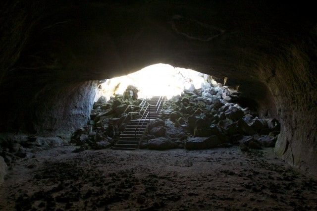
Entrance to Subway Tunnel Lava Tube
|
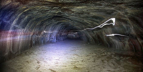
Subway Tunnel Lava Tube
|
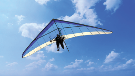
Hang Glider Above Hat Creek
|
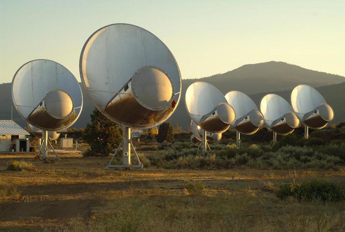
The Allen Telescope Array. Image by Seth Shostak
|
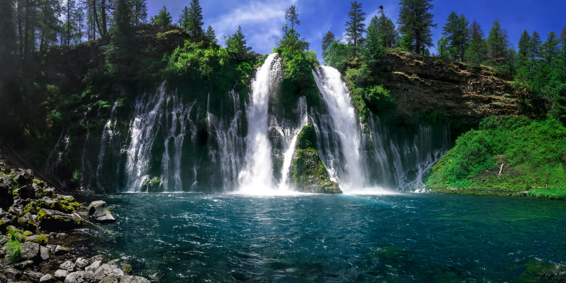
Burney Falls
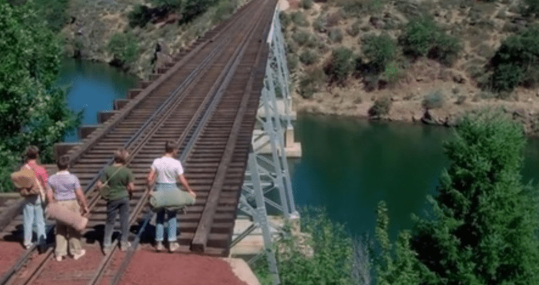
Bridge Scene from Stand By Me Movie